The “Coal Bed and Key Stratigraphic Unit Correlation Chart” is an on-going project that is intended to provide a stratigraphic framework for all energy-related studies in the Southwest Virginia Coalfield.
The goals of the chart are to:
- Synthesize “modern” detailed geologic mapping, coal quality studies, and coal bed extent maps published between 1961 and 2001 into a single regional stratigraphic system;
- Standardize and normalize the regional stratigraphic system to make it compatible with current and future electronic data management;
- Act as a reference guide between the current stratigraphic system and electronic data management tools with the published geologic maps, historic reports, and the key topical reports they were extracted from;
This chart provides a framework to bring order, promote regional consistency, and manage the tremendous volume of coal information available. This is important because even in the most advanced geologic and geo-spatial databases, we continue to manage our data by coal bed name and location. Attributes such as coal bed thickness, quality, geologic structure, and mine footprint data are “nested” within a coal bed surface. This chart provides the “z” component, where “z” includes elevation and stratigraphic position.
To date, we have identified 22 marine zones (used as marker horizons to provided geologic accuracy) and 78 named coal bed horizons within the ~5150 feet of coal-bearing stratigraphy and +1500 square miles of the Southwest Virginia Coalfield region. We are working to correlate the more than 300 historic coal bed names used in Virginia to the standardized list.
About 50 of the 78 coal beds have significant regional extent and about 40 of these report some amount of production each year. This information is particularly useful in providing quick and accurate customer assistance, a framework for the U.S. Geological Survey's NCRDS, compiling geologically meaningful production data, and placing abandoned coal mine maps (that often use local or historic coal bed names from the 1920’s to 1950’s) into the proper coal bed horizons.
Some coal beds such as the Splash Dam, Upper Banner and Lower Banner have been correlated very consistently within the Southwest Virginia Coalfield and have few local or secondary names. Conversely, the Imboden coal zone, an important historic and regional producer that extends beyond Virginia into Kentucky and West Virginia has more than 20 local and secondary names, in Virginia alone including Blue Crystal? Blue Gem, Burnwell, Campbell Creek, Freeburn, Lower Bolling, Lower Campbell Creek, Lower Elkhorn, Lower Marrowbone, Mason No. 2?, Mason No. 3?, No. 1, No. 2, No. 3., No. 2 Gas, Path Fork, Pond Creek, Upper Bolling, Upper St. Charles, Upper War Eagle, and Warfield.
Preliminary correlations for the published geologic quadrangle maps are complete. This data is being used for the related coal projects discussed above. A second, more detailed review to verify and supplement the data before full public release is about 45 percent complete. Currently compiled in MS Excel format to take advantage of row- and column-based data entry and wide distribution format, intended products include both paper and electronic format county summaries, detailed correlation data by report to document references, and possibly an interactive database application that will be web accessible.
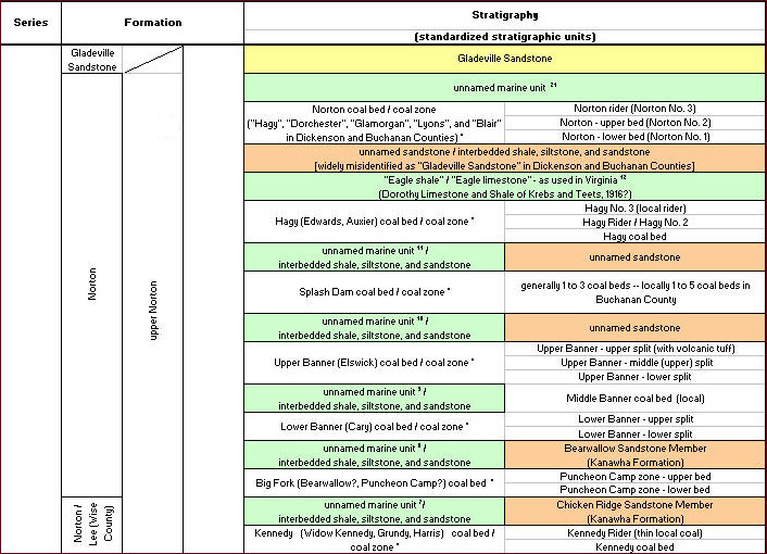
Small snapshot of the Coal bed and Key Stratigraphic Unit Correlation Chart.
Updated and working copies of the data are available upon request. An Excel spreadsheet draft version of the master portion of the Coal Bed and Key Stratigraphic Unit Correlation Chart is available for download.