Earthquakes are natural geologic events that remind us that we are living on a dynamic planet. For thousands of years, humans have observed the occurrence of seismic events across the world. In modern times, earthquakes are more destructive due to increasing development and population density. Today, millions of dollars of damages can result from a single earthquake.
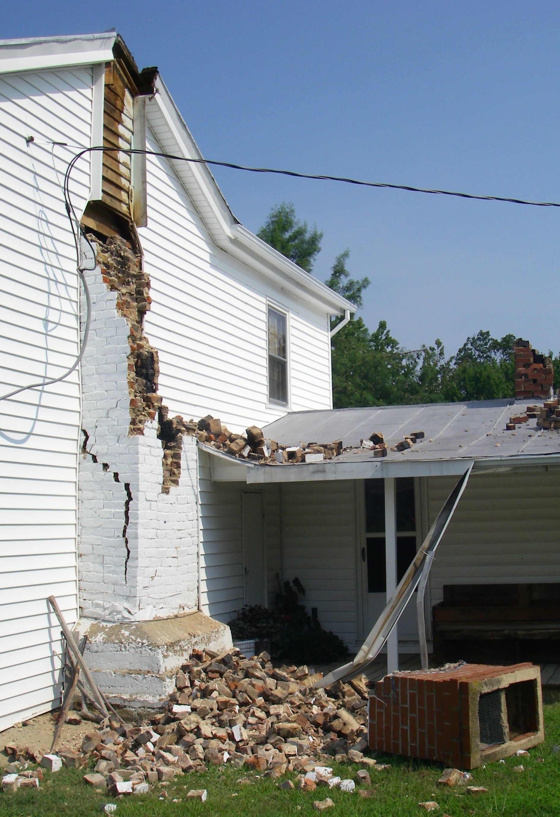
Chimney damage in Louisa County
caused by the 2011 Mineral earthquake.
Earthquakes occur underground along geologic faults. Although Virginia has many faults, nearly all of them are inactive. Most earthquakes in Virginia are not associated with a known fault, but occur within three distinct seismic zones: the Eastern Tennessee Seismic Zone (ETSZ) includes Lee County in far southwestern Virginia; the Giles County Seismic Zone (GCSZ) extends through the New River Valley; and the Central Virginia Seismic Zone (CVSZ) includes the cities of Richmond and Charlottesville. Although these seismic zones have been defined, there remains much to learn about seismicity in the Commonwealth.
Seismometers have actively been monitoring earthquakes in Virginia since the 1960s. These instruments record ground motion data that help scientists better understand modern eastern earthquakes and the faults that trigger them. Information about older earthquakes that occurred prior to seismometer emplacement, however, can only be found in historic records, such as newspapers or personal accounts. In Virginia, a written record of earthquakes exists back to the 18th century. Evidence of pre-historic earthquakes may also exist, preserved within the geologic record. Examples of such paleoseismic evidence include offsets in soil or soft sedimentary deposits, damage to cave formations, and liquefaction features such as "sand dikes" or "sand boils."
Seismic Hazard Mapping
On August 23rd 2011, Virginia's largest recorded seismic event shook central Virginia, causing almost $90 million in local damages. Residences, schools, and other buildings as far away as Baltimore, Maryland suffered structural damage from the 5.8Mw earthquake. In total, damages amounted to at least $300 million (2011 GEER report). In response to this event, the Federal Emergency Management Agency (FEMA) issued a major disaster declaration (DR-4042) to offer assistance to the residents and businesses that suffered damages in central Virginia.
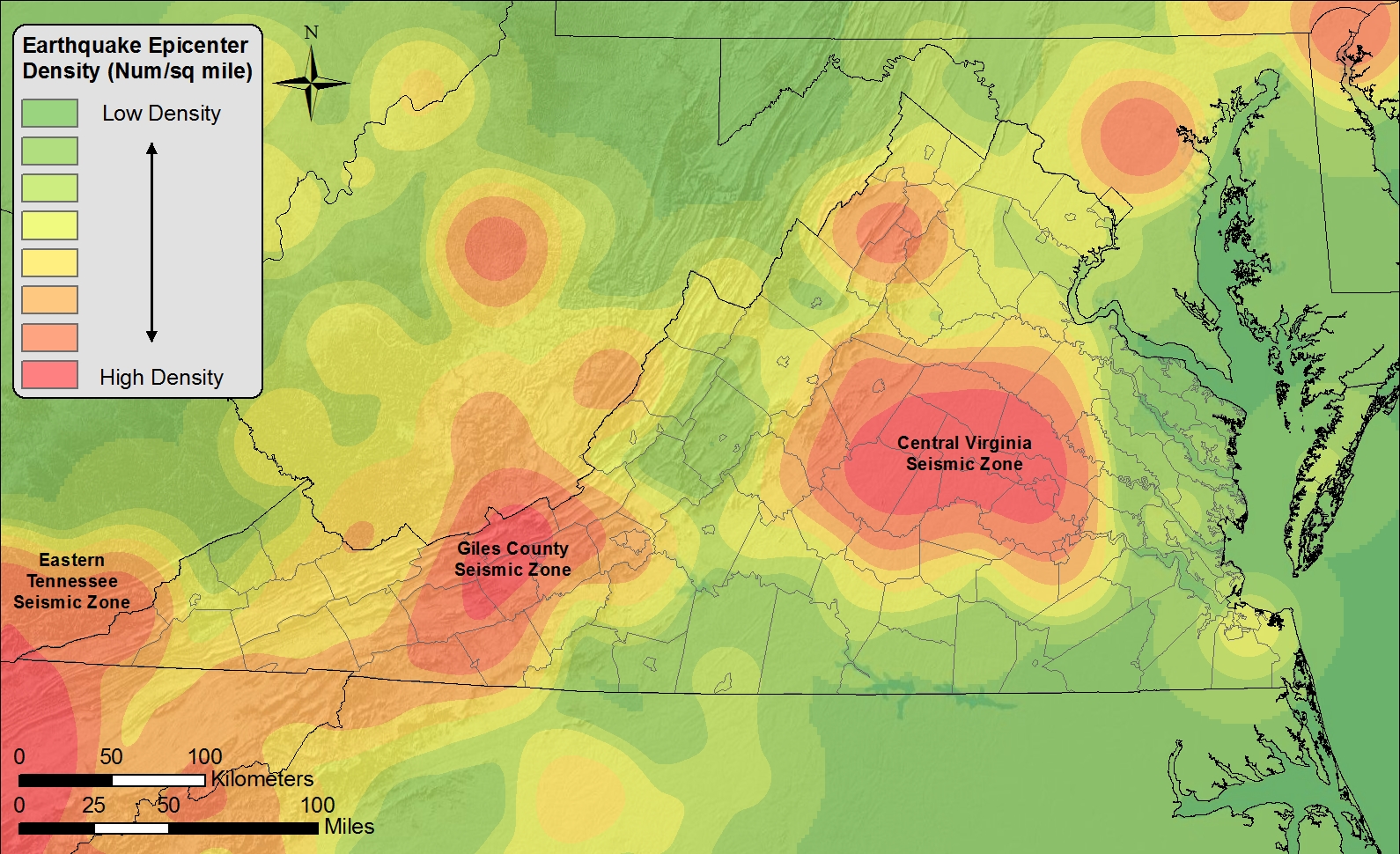
Earthquakes have been recorded in Virginia for hundreds of years. Most events relate to three distinct seismic zones.
In addition, the Virginia Department of Emergency Management provided funding through the FEMA Hazard Mitigation Grant program to reduce the impact of future earthquakes. Geology and Mineral Resouces applied for and received a grant entitled "GIS Fault Mapping of Virginia Seismic Zones" (HGMP-4042-000-014) to assess seismic hazards in the Commonwealth.
As part of this project, our geoscientists worked in collaboration with the U.S. Geological Survey, Virginia Tech, and the College of William and Mary to study and compile evidence of modern and prehistoric earthquakes. Results, when paired with cultural and infrastructure data, aid emergency management and planning agencies to identify and mitigate hazards from future earthquakes. This project was completed and delivered to VDEM in May 2017.
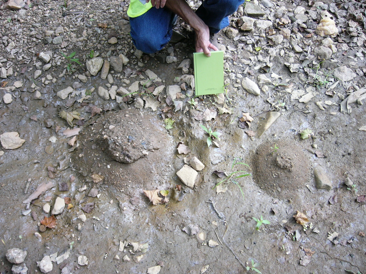
Liquefaction sand boils in alluvium along the South Anna River in Louisa County
generated by shaking from the August 23rd 2011 earthquake.
Photo courtesy of Mark Carter, USGS.
Primary goals of the FEMA earthquake hazard mapping project included:
- The development of a comprehensive ArcGIS (geographic information system) fault geodatabase for Virginia;
- Confirmation of existing fault mapping in Virginia using geological field studies;
- Use newly released (2012 and 2014 ) high-resolution LiDAR data for the 2011 epicentral area to help identify possible new faults;
- Development of a comprehensive Virginia earthquake epicenter database and report containing location and damage information;
- General earthquake hazard assessment to identify communities and infrastructure at greatest risk of future earthquake damage;
- Presentation of data products and outreach materials to planners and emergency management agencies in seismically active areas to help reduce earthquake hazards in Virginia.
Additional Seismic Resources:
Seismic Stations in Virginia
Seismic Publications
2011 Mineral earthquake FEMA disaster declaration
In the Event of an Earthquake
USGS: EQ Hazards Program
Virginia Tech Seismological Observatory
US Geological Survey Earthquake Hazards Program
Center for Earthquake Research and Information (CERI)
Incorporated Research Institutions for Seismology (IRIS)
EarthScope US Seismic Array
Seismometers in Virginia
Earthquake Facts
Deliverables
A variety of products were created for this fault mapping project and delivered to VDEM in May 2017. They include GIS files, maps and reports in PDF format, outreach materials, and PowerPoint presentations.
These four deliverables are available for download as ZIP files and are described below.
Deliverable Report (ZIP file containing a PDF document and four PDF map plates)
This document describes the processes used to compile project data, key findings from the study, and the materials delivered to VDEM. This report is a good place to start to learn more about the project tasks and deliverables. It also includes map plates showing faults compiled in the three seismically active areas of Virginia and a map of historic and modern earthquake epicenters.
Fault Geodatabase (ZIP file containing an ArcGIS geodatabase, four ESRI map documents, and geodatabase metadata)
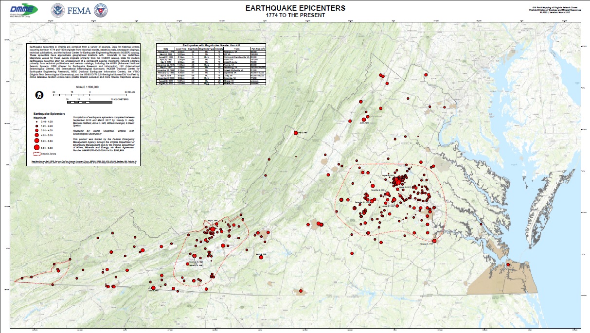
This ZIP file contains an ESRI ArcGIS geodatabase containing multiple point, line and polygon feature classes representing significant faults (lines), structural zones (polygons), earthquake epicenters (points), and additional associated features. Fault and structural zone data was compiled only for the seismically active areas of Virginia. The epicenter feature class includes earthquake locations throughout Virginia between 1774-2017. Please see the metadata for detailed descriptions of each feature class.
The download also includes map document files (.mxd) that can be used to conveniently view the GIS fault data. There are four maps included in the download. Three of these maps display the compiled fault data for the individual seismic zones: the Central Virginia Seismic Zone (CVSZ), Giles County Seismic Zone (GCSZ), Eastern Tennessee Seismic Zone (ETSZ). An additional map shows the locations of historic and modern earthquake epicenters. These map documents also provide the basis for Plates 1-4 of the deliverable report.
Earthquake History Report (ZIP file containing DGMR Publication 185, associated Appendices and Epicenter Map)
This download contains PDF documents that describe the earthquake history of Virginia. The “Seismic History of Virginia” (Publication 185) provides a general background on earthquakes, how they are measured, and how Virginia fits into the Earth’s tectonic setting. It also provides detail on the Commonwealth’s largest earthquakes (greater than 4.5 magnitude) and includes information on reported damage.
A list of earthquakes reviewed for this report is included in Appendix A and is the source for the earthquake epicenter point feature class included with the ArcGIS fault geodatabase (see above). These earthquakes are also included in a map on Plate 1 of the report. In addition, DGMR reviewed hundreds of newspaper articles, and identified more than 180 newspaper articles that provided additional details about historical earthquakes in Virginia. These articles have been compiled into a chronological bibliography in Appendix B.
Outreach Materials (ZIP file containing outreach materials and PowerPoint presentations delivered to planners and emergency managers)
Geology and Mineral Resources' geologists presented the findings of the study and project deliverables at scheduled meetings in each of the seismically active areas of Virginia. This download includes the PowerPoint presentations given at those meetings as well as outreach material included in a packet given to meeting attendees.
![]()