The Southwest Virginia Coalfield contains some of the lowest sulfur, lowest ash, and highest BTU content bituminous coal in the Appalachian basin. The high quality of Virginia’s coal makes it well suited as a steam coal for electrical power generation in the United States. It also serves a growing demand from the international steel industry for high quality coking coal. As an important contributor to economic growth in Virginia, coal is a valuable mineral resource. Based upon annual production figures and the unit values of coal mined in Virginia reported by the U.S. Energy Information Administration (EIA, 2010a; 2010b), the value of coal mined in 2009 is estimated to be about 1.6 billion dollars.
Despite the increased unit value of coal in recent years, production in Virginia has shown a marked decline as the lower production cost reserves have been depleted. Compared to 1990, the year of peak production in Virginia with nearly 46.6 million short tons of coal mined, a total of 21.2 million tons were produced in 2009 (EIA, 2010a). Coal production in Virginia is expected to continue to decline in the coming decades. It is thus critical that Virginia complete an accurate assessment of its remaining coal and gas resources to support current and future mining activities and safety initiatives.
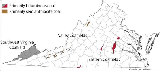
Figure 1: Coalfields of Virginia
NCRDS State Cooperative
Geology and Mineral Resources has worked cooperatively with the U.S. Geological Survey (USGS) for many years to better define the future availability of coal, oil, and gas resources in Virginia. This includes participation in the National Coal Resources Data System (NCRDS) State Cooperative Program. We provide accurate and reliable coal point and stratigraphic information for the USGS NCRDS database by utilizing an extensive resource of gas and oil well logs, including driller logs, completion reports, and geophysical logs.
In those regions where data density is sufficient, it is anticipated that the results of geologic modeling will provide the capability for assessing the remaining coal reserves for selected, high priority coal beds.
In 2005, the USGS NCRDS legacy database contained about 10,500 coal data points with over 143,000 stratigraphic records in forty-eight 7.5-minute quadrangles in Southwest Virginia (Figure 2). Beginning in 2001, the USGS provided support for us to verify and edit Virginia records contained in the NCRDS. A quality control protocol was developed for reviewing the earlier coal information and realigning the coal bed correlations to the Geohydrology of Southwest Virginia stratigraphic framework (GEOHY).
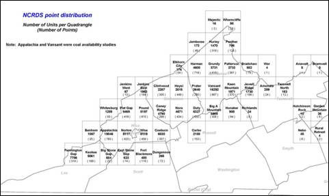
Figure 2: Distribution of USGS NCRDS legacy data points in the Southwest Virginia Coalfield
From 2005 to present our geoscientists have verified and re-correlated point and stratigraphic data and compiled “new” coal point information using the NCRDS database format for selected 7.5-minute quadrangles in the Southwest Virginia Coalfield. Currently this dataset contains 2,323 coal data points with 79,593 stratigraphic records. The data serves to advance the development and utilization of a three-dimensional geologic model that depicts the mineable coal beds and significant natural gas reservoirs in the Southwest Virginia Coalfield.
Other work completed to date as part of the State Cooperative Program includes:
- Between 1985 and 1989, Geology and Mineral Resources and USGS geologists completed detailed geologic mapping at 1:24,000-scale in the coal-bearing regions of seven counties in southwest Virginia as part of the GEOHY project. By 1992, a total of 49 7.5-minute quadrangle geologic maps had been published covering the Southwest Virginia Coalfield. These maps are available for purchase or free download from the Web Store.
- We continues to update and re-correlate coal information in the NCRDS database, adding new coal records as they become available.
- Our staff have compiled coal bed methane resource data for wells producing from the Pocahontas #3 and #6 coal beds in the Oakwood Gas Field.
- Additional studies have made contributions to the USGS Coalbed Assessment Project, the USGS Geologic Names Lexicon (GEOLEX), and investigations of Devonian shale gas potential.
Relevance and Impact
Geology and Mineral Resources expects to continue gathering data to support a better understanding of the stratigraphic and structural framework of coal and gas resources in Virginia. This data will complement the goals of the USGS NCRDS program that seeks to evaluate energy resources on a national scale.
All data collected as part of this ongoing project are available at our Charlottesville office.
Acknowledgments
This work is supported by a grant from the United States Geological Survey (USGS).
Selected References:
Le Van, D.C., 1959, A review of oil and gas in Virginia: Virginia Minerals, v. 5, n. 2, p. 1-7.
Nolde, J.E., 1994, Fuel resources of the Southwest Virginia Coalfield, in Geology and Mineral Resources of the Southwest Virginia Coalfield: Virginia Division of Mineral Resources Publication 131, p. 137-141.
U.S. Energy Information Administration (EIA), 2010a, Annual Coal Report 2009, Table 1, Coal Production and Number of Mines by State and Mine Type, 2009-2008: http://www.eia.doe.gov/cneaf/coal/page/acr/acr_sum.html
U.S. Energy Information Administration (EIA), 2010b, Annual Coal Report 2009, Table 28, Average Sales Price of Coal by State and Mine Type, 2009, 2008: http://www.eia.doe.gov/cneaf/coal/page/acr/acr_sum.html
U.S. Geological Survey (USGS), 1995, National Oil and Gas Assessment of Conventional Plays within the Appalachian Basin Province: U.S. Geological Survey Digital Data Series DDS-30, USGS Central Energy Team, Denver, Colorado.
U.S. Geological Survey (USGS), 2002, Assessment of Undiscovered Oil and Gas Resources of the Appalachian Basin Province, 2002: National Assessment of Oil and Gas fact sheet: http://pubs.usgs.gov/fs/fs-009-03/