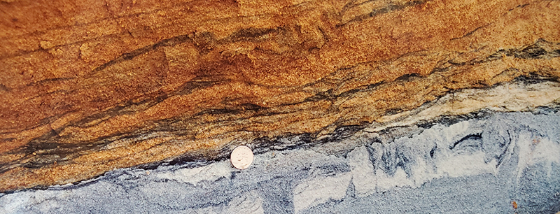
Heavy mineral laminae observed in Neogene sands from the former Old Hickory Mine near Stony Creek, VA (photo courtesy of Rick Berquist, Virginia Geology and Mineral Resources Program)
Virginia Energy is working in partnership with the U.S. Geological Survey Earth Mapping Resources Initiative (Earth MRI) to create maps that will stimulate domestic exploration for mineral resources critical to U.S. security and economic prosperity. This work is designed to support the goals of Federal Executive Order 13817 to strengthen and sustain our Nation's critical mineral supply chains. The Earth MRI Program seeks to "improve topographic, geologic, and geophysical mapping of the United States and make the resulting data and metadata electronically accessible". For a snapshot of all of the federally-funded projects supported through the program, check out their Earth MRI Acquisitions Viewer.
Virginia Energy recently completed two heavy mineral placer studies along the eastern Piedmont and western Coastal Plain of Virginia. These project areas as known as the Earth MRI Placer Ti-Zr-REE Virginia Focus Area. This work was implemented in two phases of work: Phase 1, which consists of four project areas in the Fall Zone and Coastal Plain (Fiscal Year 2019-2020), and Phase 2, five 7.5-minute quadrangles located along and just west of the Fall Zone in the Eastern Piedmont of Virginia.
Existing geochemical and geophysical datasets provided insights into anomalies associated with titanium, zirconium, and rare earth element (REE) bearing deposits. Historical mining operations in the vicinity of Stony Creek and Emporia, VA also provided rationale for new data collection needs. Recently, Atlantic Strategic Minerals have resumed a new mineral sands operation within the Old Hickory deposit, the formerly mined paleoplacer deposit (https://www.atlanticstrategicminerals.com/).
The Earth MRI initiative has also supported and fostered increased collaboration between neighboring state geological surveys and the USGS for regional mineral and geochemical resource assessments. The North Carolina Geological Survey is leading an effort to characterize REE mobilization and enrichment in granitoid regolith in the southeastern U.S. Virginia and South Carolina are partnering with North Carolina to assess granitoid plutons across the Piedmont province that may have similar characteristics to known ion clay adsorption deposits in China, where the majority of the heavy rare earth elements (HREE) are sourced from. This study is novel for the U.S. and Virginia and can serve as a model for potential domestic HREE occurrences.
Geologists have also focused on the potential for critical minerals to exist in mine waste across the Commonwealth. We recently completed an inventory mine waste sites including mine tailings and piles that could host critical minerals based on their historical mining operations. More information on this effort is provided in the Current Work section.
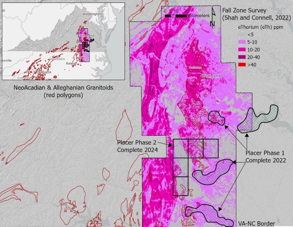
Recently completed Earth MRI work (Placer Phase 1 and 2), geophysical survey footprint (Shah and Connell, 2022) and focus areas for ongoing characterization of REE in granitoid regolith
Goals
Strengthening the critical mineral supply chain - Placer deposits of heavy minerals that occur in unconsolidated fluvial and nearshore sediments in the inner Coastal Plain of Virginia are a proven economic resource for titanium (Ti), zirconium (Zr), and rare earth elements (REE) (Berquist and others, 2015; Bern and others, 2016; Shah and others, 2017). These commodities are among those identified by the USGS in 2018 as "essential to the economic and national security of the United States (Fortier and others, 2018). The critical commodities are concentrated in heavy minerals such as ilmenite, rutile, leucoxene, zircon, and monazite. These minerals occur in trace amounts in late Proterozoic- to Paleozoic-age igneous and metamorphic rocks in the eastern Piedmont, and once liberated by weathering, can be concentrated in sediments due to their relatively high specific gravity (2.9 g/cm3). Igneous bedrock sources in proposed mapping areas also have the potential for hosting residual deposits of economic minerals in clay-rich regolith, concentrated by chemical weathering processes. A major objective of these projects is to gain a better understanding of the geologic processes that influence geochemical mobility, transport, and concentration of economic critical minerals. We expect to provide new geologic and geochemical data that will lead to exploration by the private sector.
Improving geologic map coverage - The best available geologic map for a large portion of Virginia's Coastal Plain is the 1:250,000-scale geologic map by Mixon and others (1989). While this map is an excellent resource, it does not provide sufficient detail for many needed decisions related to public safety, environmental protection, and economic development. Since 2000, Virginia has worked through the National Cooperative Geologic Mapping Program, STATEMAP component to improve the availability of detailed geologic maps. This effort has resulted in a new 1:100,000-scale geologic map of the Williamsburg 30- x 60-minute quadrangle (Berquist, 2013) and thirteen 1:24,000-scale geologic quadrangle maps. In addition, two quadrangles in the Petersburg area were mapped in cooperation with the National Park Service (Occhi and others, 2018). Despite this effort, significant areas in the Coastal Plain lack 1:100,000-scale or better map coverage. As part of the new mapping efforts, we compiled new 1:100,000-scale geologic maps for target project areas identified in the Earth MRI Placer Ti-Zr-REE deposits, Virginia Focus Area. These digital map products will result in improved map availability in the Earth MRI critical minerals resource focus area. Newly acquired airborne magnetic and radiometric surveys across the Fall Zone of Virginia and Eastern Piedmont have helped Geologists in new mapping efforts as well as in the evaluation of potential economic deposits. More information of the USGS airborne geophysical efforts can be found within their Earth MRI acquisitions viewer page.
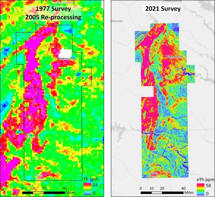
Improved geophysical coverage (Shah and Connell, 2022) helps streamline new mapping efforts and provides a clearer picture into potentially prospective areas that may host critical minerals
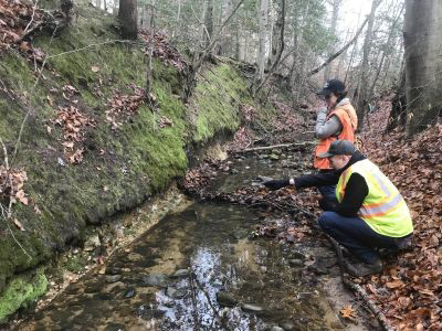
Geologists observing an exposure in a creek in the Earth MRI FY-19-20 focus area
Geologists collecting core samples from within an Earth MRI project area
Making geologic data electronically available - Most published geologic maps in the Coastal Plain are only available in hard copy format. Some recent maps are available in GIS, with formats ranging from separate shapefiles with minimal attribution to fully attributed NCGMP09 geodatabases. Geologic Map Schema (GeMS) compliant databases (formerly NCGMP09) have been created for the Phase 1 and Phase 2 project areas. These maps and geodatabases are available to the public with complete metadata. The geodatabases also support the planned 1:100,000-scale geologic maps and geodatabases of the Emporia 30- x 60-minute quadrangle and the Richmond metropolitan area. The GeMS geodatabase compilations will support the USGS objective to create a three-dimensional (3-D) digital geologic map of the United States.
Current Work
Earth MRI Virginia Placer Area (FY19-20) - Phase 1
USGS Grant No. G19AC00260 - Status: Completed
Four project areas located in the Virginia Coastal Plain were targeted based on National Uranium Resource Evaluation (NURE) radiometric equivalent thorium (eTh) geophysical anomalies and NURE stream sediment data (i.e. hafnium) (Figure 1). The project areas overlay and cross-cut 24 different quadrangles at variable extents, and range in size from approximately 84 to 282 square kilometers. The four areas extend from the Virginia Fall Zone eastward into the Atlantic Coastal Plain.
Virginia Energy compiled existing geologic maps and conducted new geologic mapping and sampling in the project areas. We produced 1:100,000-scale geologic maps and a GeMS Level-2 compliant geodatabase. The geologic maps display surficial geology throughout the project areas, sample locations, mineral resources, cross-sections, and provide a full explanation of geologic units. Additionally, 29 auger grab samples and 24 stream sediment samples were collected to characterize geologic units and assess the likelihood for economic mineral occurrences.
PDF copies of the geologic maps, a GeMS geodatabase, and a technical open-file report are avaialbel in the Virginia Energy web store.
Sample Locations (FY19-20):
Sample Location Pictures (PDF)
Earth MRI Virginia Placer Area (FY21-22) - Phase 2
USGS Grant No. G21AC10499 - Status: Completed, Pending USGS Review
The second phase of the Earth MRI includes the compilation of geologic map data in five 7.5-minute quadrangles located along and just west of the Virginia Fall Zone. The goal of this phase is to expand the 1:100,000-scale geologic mapping into additional areas that are prospective for critical mineral resources. The second phase was completed in 2024, and these data products will be uploaded to our webstore in early 2025.
Field Methods Implemented
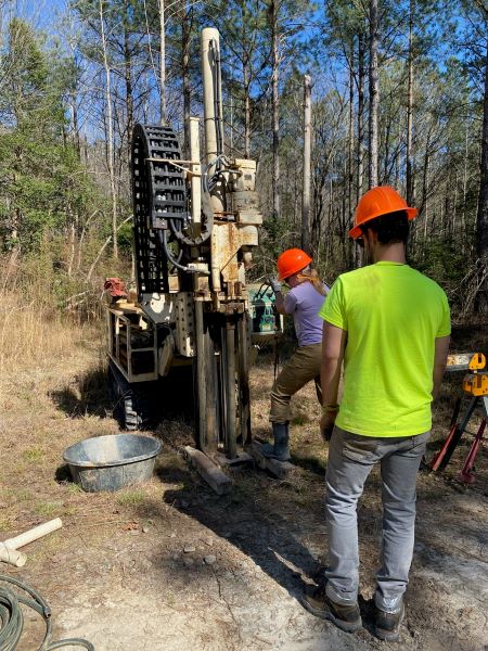
A major objective of these projects is to provide detailed geologic map coverage and analytical analyses for samples that may host critical minerals. Due to the lack of outcrop exposures in the Coastal Plain of Virginia, geologic mapping commonly involves the use a drill rig to obtain subsurface samples from depth to characterize the lithology and correlate units across the map area. Many grab samples were collected via a stainless-steel hand auger or from drill rig auger cuttings for geochemical and mineralogical analyses. To evaluate the economic mineral fractions of grab and stream sediment samples, we concentrated heavier minerals via gravity separation using a three-turn Humphrey spiral. These concentrated samples represent the total heavy mineral (THM) fraction of the bulk samples. These samples were submitted to an analytical laboratory, where they were further concentrated by heavy liquid separation and analyzed to obtain detailed mineralogy on the respective THM fractions.
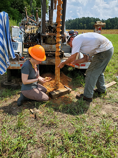
Geologists examining drill cuttings from Pliocene-age sand
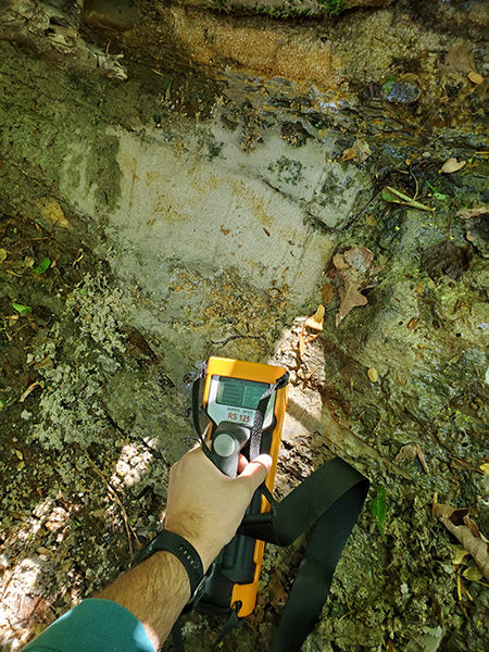
Geologist field screening an outcrop for naturally occurring radioactivity using a portable gamma spectrometer
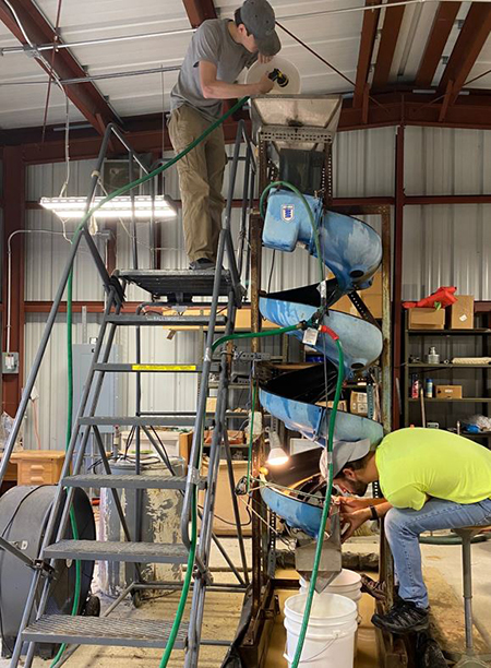
The three turn Humprey spiral used to separate lighter and denser minerals
Characterization of REE in Regolith - Earth MRI NC-SC-VA Joint Initiative
USGS Grant No. G23AC00459 - Status: In Progress, anticipated completion in 2026
The North Carolina Geological Survey is leading a multi-state effort to characterize the potential for REE to occur within weathered regolith that occurs above Alleghanian and NeoAcadian aged granitoids in the Piedmont. This collaborative involves the South Carolina Geological Survey and Virginia, and field sampling events are underway as of early 2025. Numerous granitoids are present in the Central and Eastern Piedmont of Virginia that may host enriched REE within the regolith profile, which extends from the base of the weathered rock up through the saprolite and soil profiles. We are accomplishing sampling via multiple methods including collection of cores via direct-push technology drilling methods and sampling of existing in-situ exposures.
Mine Waste Inventory
USGS Grant No. G23AC00522 - Status: Completed
Virginia Energy's Geology and Minerals Resources and Mineral Mining Programs completed a statewide inventory of mine waste piles (greater than 2,000 square meters) that may have potential to host critical minerals, as byproducts of historical mining. The purpose of this inventory is to inform future land management, planning, and remediation decisions in Virginia by identifying nonfuel mine waste sites that may contain critical mineral resources. Records were compiled into a geodatabase following a USGS provided framework. We anticipate applying for future funds to begin a second phase of assessment involving the characterization of waste piles from an existing or historical mine site.
Selected References:
Bern, C.R., A.K. Shah, W.M. Benzel and H.A. Lowers, 2016 The distribution and composition of REE-bearing minerals in placers of the Atlantic and Gulf coastal plains, USA Journal of Geochemical Exploration Vol. 162, p. 50-61.
Berquist, C.R., Jr., 2013, Geologic map of the Williamsburg 30- x 60-minute quadrangle, Virginia: Virginia Division of Geology and Mineral Resources, Open-File Report 2013-07, 1:100,000-scale map.
Berquist, C.R., A.K. Shah, and A. Karst, 2015, Placer deposits of the Atlantic Coastal Plain: stratigraphy, sedimentology, mineral resources, mining and reclamation: Cove Point, Maryland, Williamsburg and Stony Creek, Virginia, Society of Economic Geology Guidebook, 50, 48.
Dischinger, J.B., Jr. 1987, Late Mesozoic and Cenozoic Stratigraphic and Structural Framework near Hopewell, Virginia: U.S. Geological Survey Bulletin 1567, 48 p.
DMME (Department of Mines, Minerals and Energy), 2020, Annual production reports submitted by mine operators, Division of Mineral Mining.
Duval, J.S., Carson, J.M., Holman, P.B., and Darnley, A.G., 2005, Terrestrial radioactivity and gamma-ray exposure in the United States and Canada: U.S. Geological Survey Open-File Report 2005-1413.
Fortier, S.M., Nassar, N.T., Lederer, G.W., Brainard, J., Gambogi, J., and McCullough, E.A., 2018, Draft critical mineral list - Summary of methodology and background information - U.S. Geological Survey technical input document in response to Secretarial Order No. 3359: U.S. Geological Survey Open-File Report 2018-1021, 15 p.
Grossman, Jeffrey N., 1998, National Geochemical Atlas: The geochemical landscape of the conterminous United States derived from stream sediment and other solid sample media analyzed by the National Uranium Resource Evaluation (NURE) Program: U.S. Geological Survey Open-File Report 98-622, U.S. Geological Survey, Reston, VA.
Hawkins, D.W., and Lassetter, W.L., 2022, Geologic map compilation and geochemical investigations in the Earth MRI Virginia Fall Zone placer focus area: Virginia Department of Energy, Geology and Mineral Resources Program Open-file Report 2022-01, 50 p. and Appendices.
Johnson, G.H. and Berquist, C.R., Jr., 1989, Geology and mineral resources of the Brandon and Norge quadrangles, Virginia: Virginia Division of Geology and Mineral Resources Publication 87, 28 p.
McClenaghan, M.B., 2011, Overview of common processing methods for recovery of indicator minerals from sediment and bedrock in mineral exploration: Geochemistry, Exploration, Environment, Analysis, Vol 11, p. 265-278.
Mertie, J.B., Jr., 1975, Monazite placers in the southeastern Atlantic States: U.S. Geological Survey Bulletin 1390, 41 p.
Mixon, R.B., Berquist, C.R., Newell W.L., and Johnson, G.H., 1989, Geologic map and generalized cross-sections of the Coastal Plain and adjacent parts of the Piedmont, Virginia: U.S. Geological Survey Map I-2033, one sheet.
Occhi, M.E., 2021, Geologic Map of the Hopewell quadrangle, Virginia: Virginia Department of Energy, Geology and Mineral Resources Program Open-File Report 2021-04, 1:24,000-scale map.
Occhi, M.E., Blanchette, J.S. and Berquist, C.R., Jr., 2017, Geologic Map of the Chester quadrangle, Virginia: Virginia Division of Geology and Mineral Resources 2017 STATEMAP Deliverable, 1:24,000-scale map.
Occhi, M.E., Berquist, C.R., Jr., Latane, V.M., and Blanchette, J.S., 2018, Geology of the Petersburg National Battlefield and adjacent areas: Virginia Division of Geology and Mineral Resources 2018 NPS Grant Deliverable, 29 p.
Pirkle, F.L., Pirkle, W.A., and E.C. Pirkle 2007 Heavy Mineral Sands of the Atlantic and Gulf Coastal Plains, USA in Developments in Sedimentology, Vol. 58, p. 1144-1232 https://doi.org/10.1016/S0070-4571(07)58045-3.
Shah, A.K., Bern, C.R., Van Gosen, B.S., Daniels, D.L., Benzel, W.M., Budahn, J.R., Ellefsen, K.J., Karst, A., Davis, R., 2017, Rare earth mineral potential in the southeastern U.S. Coastal Plain from integrated geophysical, geochemical, and geological approaches: Geological Society of America Bulletin Vol. 129, Issue 9-10, DOI: 10.1130/B31481.1.
Van Gosen, B., D. Fey, A. Shah, P. Verplanck, and T. Heofen, 2014, Deposit model for heavy-mineral sands in coastal environments, U.S. Geological Survey Scientific Investigations Report 2010-5070-L, 51 p.
Weems, R.E., Schindler, J.S., and Lewis, W.C., 2010, Detailed sections from auger holes in the Emporia 1:100,000-scale quadrangle, North Carolina and Virginia: U.S. Geological Survey Open-File Report 2010-1121, 288 p.