Virginia’s geological survey was created in 1835 by the Virginia General Assembly. The intent of the survey was to characterize and map the extent of Virginia’s mineral resources, especially coal. The Geological Survey of Virginia, as it was known at that time, was the fifth state geological survey created in the United States. William Barton Rogers served as the survey’s first director. From the compilation of Rogers’ reports and maps, the first comprehensive geologic map of Virginia was produced in 1884. Rogers was also professor of natural philosophy and chemistry at the College of William and Mary and later founded the Massachusetts Institute of Technology in 1865. Mount Rogers, the highest point in Virginia at 5,729 feet, was named for William Barton Rogers.
In 1907, Thomas Leonard Watson published “Mineral Resources of Virginia.” This publication was a comprehensive review of the mineral resource occurrences in the state and was released to coincide with the 300th anniversary of the Jamestown settlement. Watson was appointed Director of the survey in 1908.
Geology and Mineral Resources has had several names since it inception in 1835 including: Geological Survey of Virginia (1835-43), Virginia Geological Survey (1908-54), Division of Geology (1954-57), Division of Mineral Resources (1957-2008). In 1985, the Division of Mineral Resources became a division of the newly created Department of Mines, Minerals and Energy. In 2008, our name changed once again to the Division of Geology and Mineral Resources to further emphasize our role as Virginia's geological survey. Finally, October 1, 2021, "Geology and Mineral Resources" has become part of the newly renamed Department of Energy.
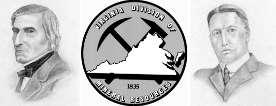
Pencil sketches of William Barton Rogers, first State Geologist (left) and Thomas Leonard Watson (right) drawn by Christine Schmiel. These sketches were made available to us by Professor Grant Goodell, University of Virginia.