A landslide is the downslope transport of a mass of soil and rock material and refers to a number of different varieties of ground movement landforms and processes. The primary driving force for a landslide is gravity, but other factors may contribute to the failure of a slope. Landslides are usually triggered by heavy rainfall, rapid snow melt, oversteepening of slopes by stream incision, or earthquakes, while certain man-made changes to the land, such as slope modification or drainage alteration, can greatly increase the likelihood of landslides. Landslides are capable of destroying buildings, rupturing gas, water, and sewer mains, and knocking out power and telephone lines while blocking transportation routes. Sometimes a landslide may move slowly down a slope, but often the movement can occur without warning and be extremely fast. Soil creep and slumping cause property damage gradually, whereas rock slides and debris flows can sweep away people and property instantaneously. In the United States, landslides annually cause up to $2 billion in damages and take between twenty-five and fifty lives.
Landslides occur in many manifestations and are usually classified according to the type of material involved and the mode of downslope movement. The material can range from loose earth to blocks of solid rock. These materials may then move downslope by falling, sliding or flowing. The following are some of the more important types of mass movement:
- Rockfalls entail large blocks of bedrock breaking off a cliff face and tumbling downslope.
- Rockslides occur when a detached section of bedrock slides down an inclined surface, frequently along a bedding plane.
- Earthslides involve masses of soil moving down a slip face, usually on top of the bedrock.
- Creep is the slow, continuous, imperceptible downslope movement of soil and rock particles.
- Rotational Slides or Slumps result from the rotation of a cohesive unit of soil or rock down a slip surface, leaving a curved scarp.
- Debris flows develop on steep slopes as a result of heavy rainfall that saturates the soil, which under the extra weight and lubrication breaks loose and becomes a slurry that takes everything with it, including large trees and houses. Channeled debris flows can reach speeds approaching a hundred miles an hour and strike without warning .
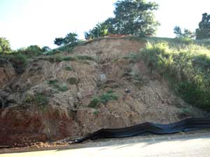
Landslides are most common in the mountainous terrain of Virginia because of the presence of steep slopes and highly fractured bedrock over shallow soils. The lower-releif areas of the Piedmont and Coastal Plain also have landslides, but they are often smaller and generated by human disturbance, such as making an oversteepened road cut. The most disastrous landslide events have been associated with heavy rainfall along the steep slopes of the Appalachian Highlands. Areas that are prone to mass movement include areas where landslides have occurred in the past; steep slopes with an angle greater than 25 degrees; and oversteepened cuts and fills, particularly due to home and road building. Research in North Carolina has revealed that about fifty-six percent of recent landslides happened on slopes that had been altered in some way by development.
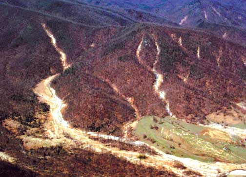
Aerial view of debris flow chutes and flood deposits from the June 27, 1995 flood at Kinsey Run, near Graves Mill in Madison County, Va.
Photo from The debris flows of Madison County, Virginia: 34th Annual Virginia Geological Field Conference Guidebook.
Significant rain events that trigger landslides occur in Virginia every 10-15 years. On June 27, 1995, an intense thunderstorm storm over Madison County triggered more than 500 debris flows. Tropical Depression Gaston (August 2004) wreaked havoc in the Richmond area, causing extensive flooding and generating a large 11-acre landslide in downtown Richmond and hundreds to thousands of smaller landslides in the greater Richmond area (Mark Carter, USGS, per comm). Virginia's deadliest natural disaster occurred on the night of August 19, 1969, when remnants of Hurricane Camille dumped over twenty-five inches of rain during a five-hour period along the Blue Ridge in central Virginia, triggering thousands of debris flows that killed 153 people. Countless buildings were destroyed and more than a hundred bridges were swept away in parts of Nelson, Amherst, and Rockbridge counties.
The potential for landslides in most of the counties in western Virginia is high. As shown in the map below, adapted from USGS Landslide Overview Map of the Conterminous United States, at least half of the Commonwealth falls into zones of high potential.
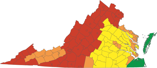
Counties in Virginia that are susceptible to landslides.
Red = high potential; orange = moderate potential; yellow = moderate to low potential; green = low potential.
The Virginia Department of Emergency Management (VDEM) provides basic information about landslides in the Commonwealth, and sponsors regional mitigation plans outlined in the Federal Disaster Mitigation Act of 2000. Unfortunately, these plans are incomplete. The problem is that there is no simple, universal methodology for determining vulnerability to landslides, and the available data provides only the broadest indications of areas that could expect a landslide. What are lacking are detailed landslide hazard maps for VDEM and other state agencies to use in planning and mitigation. So far, Page (2013), Nelson (2024), and Albemarle Counties (2024) are the only counties that has been mapped for landslide hazards by Virginia Energy.
Recently, our geologists have started using high-resolution lidar data to identify and map landslides. Lidar, which stands for Light Detection and Ranging, is a method of remote sensing that can produce a precise 3-dimensional model of the Earth's surface. Unlike aerial imagery like you would find on Google Earth, lidar can see beyond dense vegetation and forest cover to reveal the extent of landslide deformation, like scarps, tension cracks, and deposited soil. Lidar data can also help identify areas vulnerable to landslides by identifying where landslides might occur and where they might travel down slope.
Homeowners insurance does not cover landslide damage. Anyone who intends to buy or build on steep terrain should be wary of potential problems. Effective, on-site geological analysis is necessary to identify former landslide deposits and existing planes of weakness in bedrock, such as fractures, foliation, and bedding surfaces. Although the cause of most landslides cannot be mitigated, detailed geologic investigations and effective land-use practices can greatly reduce the risk.
Be Prepared! Learn More Here »
Selected References
Carter, M. W., and Berquist, C. R., Jr., 2005, A preliminary investigation of the Chimborazo Hill landslide of August 30, 2004: Virginia Minerals, v. 48, n. 4, p. 25-36.
Cruden, D. M., 1991, A simple definition of a landslide: Bulletin of the International Association of Engineering Geology, n. 43, p. 27-29.
Eaton, L. S., Bailey, C. M., and Gilmer, A. K., 2004, The debris flows of Madison County, Virginia: 34th Annual Virginia Geological Field Conference Guidebook, 27 p.
Hack, J. T., 1956, Erosion by catastrophic floods in the Ridge and Valley province, Virginia: Virginia Journal of Science, v. 7, n. 4.
North Carolina Geological Survey, 2005, When the Earth Moves (Bechtel, R., ed.): North Carolina Geological Survey Information Circular 32, 24 p.
Radbruch-Hall, D. H., R. B. Colton, W. E. Davies, Ivo Lucchitta, B. A. Skipp, and D. J. Varnes, 1982, Landslide Overview Map of the Conterminous United States, Geological Survey Professional Paper 1183, U.S. Geological Survey, Washington.
Ress, D., 2004, City damage may top $15 million: Richmond Times-Dispatch, September 1st, Section B, p. 1.
Ritter, D. F., 1986, Process Geomorphology: Wm. C. Brown Publishers, Dubuque, Iowa, 579 p.
Varnes, D. J., 1978, Slope movement types and processes, in Schuster, R. L. and Krizak, R. J., eds., Landslide Analysis and Control: Transportation Research Board Special Report No. 176, National Academy of Sciences, Washington, D.C., p. 11-33.
Virginia Division of Mineral Resources, 1969, Natural features caused by a catastrophic storm in Nelson and Amherst counties, Virginia: Virginia Division of Mineral Resources Virginia Minerals, Special Issue, 20 p.
Additional Resources:
Landslide Inventory of Albemarle and Nelson Counties (Geology and Mineral Resources)
USGS Landslide Handbook - A Guide to Understanding Landslides
USGS landslide hazards program
USGS site of debris flow hazards in the Appalachians