HyperLink
Sign In Sign In Sign Out Logout Account Account Cart Cart
 
  SEARCH    Help?         Why do we use cookies?       Privacy Policy/Disclaimer
    Home

Product Categories


Sales & Returns Policy


Spacer Image

Spacer Image
Spacer ImageReport of Investigations 005: Geology of the Clinchport quadrangle, Virginia
Spacer Image Spacer Image
Spacer ImageIn Stock
Spacer ImageYour Price: $6.00
Spacer ImageModel Number: 1173

Spacer Image
Spacer Image
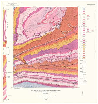
by W.B. Brent, 47 pages, map in color, 14 figures, 2 tables, 1963. Map shows the geology and mineral resources of the Clinchport 7.5-minute quadrangle. Clinchport is located in Scotty County in southwestern Virginia. It is entirely within the Valley and Ridge physiographic province. The bedrock in this quadrangle ranges in age from Cambrian to Devonian. The structure consists largely of northeastward-trending reverse faults and formations that dip southward. High-calcium limestone for cement manufacture, and dolomite for use as crushed stone are quarried within the quadrangle. Map includes cross-sections.
 Customers who bought this also bought
  Report of Investigations 037: Geology of the Salem Quadrangle, Virginia
  Report of Investigations 011: Geology of the Leesburg quadrangle, Virginia
  USGS GQ-238: Geology of the Stickleyville quadrangle, Virginia
  Salem, VA Topographic Map (1:24,000)
  Leesburg, VA-MD Topographic Map (1:24,000)
 
Spacer Image