
|
Publication 090, Part B: Geologic map of the Penhook and Mountain Valley quadrangles, Virginia
|
|
|
In Stock
Your Price: $10.50
Model
Number: 1086

|
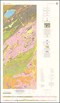
by J.F. Conley, R.G. Piepul, G.R. Robinson, Jr., E.M. Lemon Jr., and C.R. Berquist, Jr., color map with explanation, 1:24,000 scale, 1989. This map shows the bedrock geology and surficial deposits of the Penhook and Mountain Valley 7.5-minute quadrangles. These quadrangles are located in the southwestern Virginia Piedmont and include portions of Franklin, Henry, and Pittsylvania counties. The bedrock mapped in the area includes Precambrian to Ordovician formations of the Smith River Allochthon, Precambrian to early Paleozoic metamorphic rocks of the Lynchburg Group and the Candler Formation, and middle to late Paleozoic cataclastic schists. Also mapped are Mesozoic diabase dikes and Quaternary colluvium, alluvium, and terrace deposits. Rock repository locations and prospects for mica are plotted on the map and cross-sections are included. Detailed descriptions on the stratigraphy, structure, and economic geology of these quadrangles can be found in Publication 90C.
|
|
|
|
Customers who bought this also bought
|
Publication 090, Part A: Geologic map of the Rocky Mount and Gladehill quadrangles, Virginia
|
Publication 090, Part C: Geology of the Rocky Mount, Gladehill, Penhook, and Mountain Valley quadrangles, Virginia
|
Publication 077: Geology of the Sandy Level and Callands quadrangles, Virginia
|
Publication 049: Geologic Map of the Pittsville and Chatham Quadrangles, Virginia
|
Publication 089: Minerals of Albemarle County, Virginia
|
|
|
|
|
|
|
|
|