
|
Publication 090, Part A: Geologic map of the Rocky Mount and Gladehill quadrangles, Virginia
|
|
|
In Stock
Your Price: $10.50
Model
Number: 1085

|
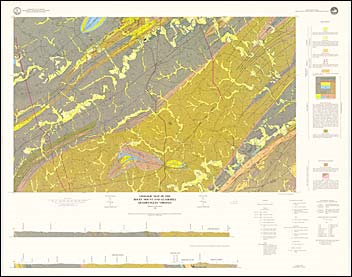
by M.B. McCollum, color map with explanation, 1:24,000 scale, 1989. This map shows the bedrock geology and surficial deposits of the Rocky Mount and Gladehill 7.5-minute quadrangles. These quadrangles are located in the southwestern Virginia Piedmont and are entirely within Franklin County. The bedrock mapped in the area includes Precambrian to early Paleozoic formations of the Smith River Allochthon, the Precambrian Lynchburg Group, and unnamed formations of the middle to late Paleozoic. Also mapped are Mesozoic diabase dikes and Quaternary colluvium, alluvium, and terrace deposits. Abandoned mines, quarries, iron furnaces, and forges are plotted on the map and cross-sections are included. Detailed descriptions on the stratigraphy, structure, and economic geology of these quadrangles can be found in Publication 90C.
|
|
|
|
Customers who bought this also bought
|
Publication 090, Part B: Geologic map of the Penhook and Mountain Valley quadrangles, Virginia
|
Publication 090, Part C: Geology of the Rocky Mount, Gladehill, Penhook, and Mountain Valley quadrangles, Virginia
|
Publication 035: Geology of the Villamont and Montvale Quadrangles, Virginia
|
Publication 089: Minerals of Albemarle County, Virginia
|
Geologic Map Of Virginia (1:500,000)
|
|
|
|
|
|
|
|
|