
|
Report of Investigations 041: Geology of the Mulberry Island, Newport News North, and Hampton quadrangles, Virginia
|
|
|
In Stock
Your Price: $6.00
Model
Number: 1209

|
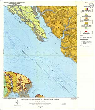
by G.H. Johnson, 72 pages, 3 maps in color, 24 figures, 4 tables, 1976. Map shows the geology and mineral resources of the Mulberry Island, Newport News North and Hampton 7.5-minute quadrangles. These quadrangles are located in the Outer Coastal Plain. They include portions of York and Isle of Wight counties and portions of the cities of Hampton, Newport News, and Poquoson. Exposed sediments are of Pliocene, Pleistocene, and Holocene age. Map includes cross-sections.
|
|
|
|
Customers who bought this also bought
|
Geologic Map Of Virginia (1:500,000)
|
Report of Investigations 018: Geology of the Williamsburg, Hog Island, and Bacons Castle Quadrangles, Virginia
|
Report of Investigations 030: Geology of the Yorktown, Poquoson West, and Poquoson East Quadrangles, Virginia
|
Report of Investigations 017: Geology of the Benns Church, Smithfield, Windsor, and Chuckatuck quadrangles, Virginia
|
Report of Investigations 028: Geology of Newport News South and Bowers Hill quadrangles, Virginia
|
|
|
|
|
|
|
|
|