Sign In
Logout
Account
Cart
SEARCH
Help?
Why do we use cookies?
Privacy Policy/Disclaimer
Home
Product Categories
Educational Materials
Fact Sheets
Geologic Publications
Topographic Maps
Virginia Minerals
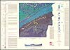
USGS GQ-1119: Geologic map of the Whitesburg quadrangle, Kentucky-Virginia and part of the Flat Gap quadrangle, Letcher County, Kentucky
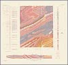
USGS GQ-238: Geology of the Stickleyville quadrangle, Virginia
USGS GQ-1668: Geologic map of the Anawalt quadrangle, West Virginia-Virginia
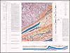
USGS GQ-745: Geologic map of the Bramwell quadrangle, West Virginia-Virginia
USGS GQ-1739: Geologic map of the Bluemont quadrangle, Loudoun and Clarke Counties, Virginia
USGS GQ-851: Geologic map of the Keokee quadrangle, Virginia-Kentucky
USGS GQ-1755: Geologic map of the Purcellville quadrangle, Loudoun County, Virginia
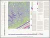
USGS GQ-951: Geologic map of the Elkhorn City quadrangle, Kentucky-Virginia and part of the Harman quadrangle, Pike County, Kentucky
USGS GQ-1769: Geologic map of the Supply quadrangle, Caroline and Essex Counties, Virginia
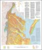
USGS MI-2033: Map and Generalized Cross Sections of the Coastal Plain and Adjacent Parts of the Piedmont Virginia

 Sign In
 Account
 Cart
Cart