HyperLink
Sign In Sign In Sign Out Logout Account Account Cart Cart
 
  SEARCH    Help?         Why do we use cookies?       Privacy Policy/Disclaimer
    Home

Product Categories


Sales & Returns Policy


Spacer Image

Spacer Image
Spacer ImageOpen File Report 21-08 Geologic Map of the Wytheville Quadrangle
Spacer Image Spacer Image
Spacer Image
Spacer ImageYour Price: $0.00
Spacer ImageModel Number: 3097

Spacer Image
Spacer Image
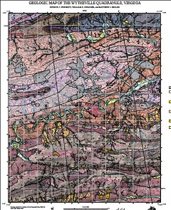
By P.C. Finnerty, W.R. Swanger and M.J. Heller, 41 x 45-inch color 1:24,000-scale geologic map, 2021. This map of the Wytheville 7.5-minute quadrangle in Wythe county, Virginia shows the distribution of Paleozoic-age sedimentary and metasedimentary rocks in map and cross-section. Surficial deposits including terrace, debris fan and alluvial deposits are also shown. Online only.
Spacer Image