HyperLink
Sign In Sign In Sign Out Logout Account Account Cart Cart
 
  SEARCH    Help?         Why do we use cookies?       Privacy Policy/Disclaimer
    Home

Product Categories


Sales & Returns Policy


Spacer Image

Spacer Image
Spacer ImageOpen File Report 20-04 Geologic Map of the north half of the Max Meadows Quadrangle
Spacer Image Spacer Image
Spacer Image
Spacer ImageYour Price: $0.00
Spacer ImageModel Number: 3090

Spacer Image
Spacer Image
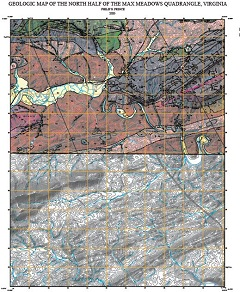
By P.S. Prince, 40 x 40-inch color 1:24,000-scale geologic map, 2020. This map of the north half of the Max Meadows 7.5-minute quadrangle in Wythe county, Virginia shows the distribution of Paleozoic-age sedimentary rocks in map and cross-section. Surficial deposits including landslide, blockslide, colluvium, terrace and alluvial deposits are also shown. Online only.
Spacer Image