
|
Your Price: $0.00
Model
Number: 3087
|
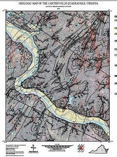
By D.B. Spears, and N.J. Evans, 40 x 42-inch color 1:24,000-scale geologic map, 2020. This map of the Cartersville 7.5-minute quadrangle in Goochland, Fluvanna, Cumberland, Louisa and Powhatan counties, Virginia shows the distribution of Proterozoic, Paleozoic and Mesozoic-age igneous and metamorphic rocks in map and cross-section. Surficial deposits including river terraces and alluvium are also shown. Online only.
|
|