
|
Your Price: $0.00
Model
Number: 3080
|
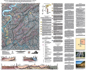
By M.J. Heller, WR. Swanger, J. Rubinstein, and M.S. Smith, 36 x 44-inch color 1:24,000-scale geologic map, 2019. This map of the Hiwassee 7.5-minute quadrangle in Carroll, Floyd and Pulaski counties, Virginia shows the distribution of Paleozoic-age sedimentary rocks and Paleozoic- to Proterozoic-age metamorphic rocks in map and cross-section. Surficial deposits including alluvium, colluvium, and river terraces are also shown. A brief report accompanied by 3 figures describes the local geology. Online only.
|
|