
|
Your Price: $0.00
Model
Number: 3078
|
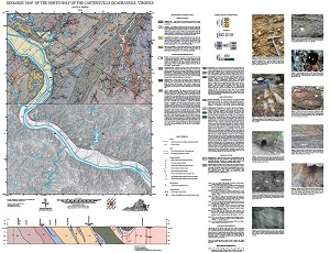
By D.B. Spears, 34 x 43-inch color 1:24,000-scale geologic map, 2019. This map of the north half of the Cartersville 7.5-minute quadrangle in Cumberland and Goochland counties, Virginia shows the distribution of Mesozoic-age igneous and fault-related rocks, and Paleozoic- to Proterozoic-age igneous and metamorphic rocks in map and cross-section. Surficial deposits including alluvium and terraces are also shown. Accompanied by 10 figures that highlight geologic features in the map area. Online only.
|
|