Virginia Department of EnergyAn official website of the Commonwealth of Virginia Here's how you knowAn official websiteHere's how you know

  HyperLink
Sign In Sign In Sign Out Logout Account Account Cart Cart
 
  SEARCH    Help?         Why do we use cookies?       Privacy Policy/Disclaimer
    Home

Product Categories


Sales & Returns Policy


Spacer Image

Spacer Image
Spacer ImageOpen File Report 17-04 Geologic Map of the Zion Crossroads Quadrangle, Virginia
Spacer Image Spacer Image
Spacer Image
Spacer ImageYour Price: $0.00
Spacer ImageModel Number: 3072

Spacer Image
Spacer Image
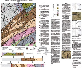
By N.H. Evans, 38 x 45-inch color 1:24,000-scale geologic map, 2017, revised April 2023. This map of the Zion Crossroads 7.5-minute quadrangle in Louisa and Fluvanna counties, Virginia shows the distribution of Mesozoic-age igneous rocks, and Paleozoic-age igneous and metamorphic rocks in map and cross-section. Alluvium and modified land are also shown. A brief report accompanied by 5 figures describes the local geology. Online only.
Spacer Image