Virginia Department of EnergyAn official website of the Commonwealth of Virginia Here's how you knowAn official websiteHere's how you know

  HyperLink
Sign In Sign In Sign Out Logout Account Account Cart Cart
 
  SEARCH    Help?         Why do we use cookies?       Privacy Policy/Disclaimer
    Home

Product Categories


Sales & Returns Policy


Spacer Image

Spacer Image
Spacer ImageOpen File Report 16-05 Geologic Map of the McDonalds Mill Quadrangle, Virginia
Spacer Image Spacer Image
Spacer Image
Spacer ImageYour Price: $0.00
Spacer ImageModel Number: 3068

Spacer Image
Spacer Image
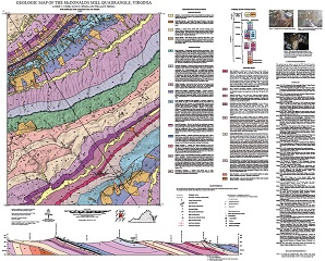
By L.V. Coiner, D.B. Spears, and W.S. Henika, 33 x41-inch color 1:24,000-scale geologic map, 2016. This map of the McDonalds Mill 7.5-minute quadrangle in Craig, Montgomery, and Roanoke counties, Virginia shows the distribution of Paleozoic-age sedimentary rocks in map and cross-section. Surficial deposits including alluvium. fans, and river terraces are also shown. Online only.
Spacer Image