Virginia Department of EnergyAn official website of the Commonwealth of Virginia Here's how you knowAn official websiteHere's how you know

  HyperLink
Sign In Sign In Sign Out Logout Account Account Cart Cart
 
  SEARCH    Help?         Why do we use cookies?       Privacy Policy/Disclaimer
    Home

Product Categories


Sales & Returns Policy


Spacer Image

Spacer Image
Spacer ImageOpen File Report 15-06 Richmond MSA Digital Compilation: Yellow Tavern Quadrangle, Virginia
Spacer Image Spacer Image
Spacer Image
Spacer ImageYour Price: $0.00
Spacer ImageModel Number: 3066

Spacer Image
Spacer Image
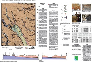
By M.E. Occhi, C.R. Berquist, Jr. and M.W. Carter, 35 x 50-inch color 1:24,000-scale geologic map, 2015. This map of the Yellow Tavern 7.5-minute quadrangle in Hanover and Henrico counties, Virginia shows the distribution of Cenozoic-age unconsolidated Coastal Plain sediments, Paleozoic-age igneous rocks, and Paleozoic- to Proterozoic-age metamorphic rocks in map and cross-section. Alluvium is also shown. A brief report accompanied by 4 figures and two tables describes the local geology. Online only.
Spacer Image