
|
Your Price: $0.00
Model
Number: 3053
|
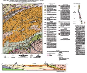
Geology by S.E. Lewis, W.E. Truman, III, P.B. Kaygi, R.S. Whitmarsh, M.J. Bartholomew, and W.S. Henika. Compiled by W.S. Henika. 37 x 41-inch color 1:24,000-scale geologic map, 2012. This map of the Riner 7.5-minute quadrangle in Montgomery and Floyd counties, Virginia shows the distribution of Paleozoic-age sedimentary rocks and Paleozoic- to Proterozoic-age metamorphic rocks in map and cross-section. Surficial deposits including alluvial and colluvial deposits are also shown. Online only.
|
|