HyperLink
Sign In Sign In Sign Out Logout Account Account Cart Cart
 
  SEARCH    Help?         Why do we use cookies?       Privacy Policy/Disclaimer
    Home

Product Categories


Sales & Returns Policy


Spacer Image

Spacer Image
Spacer ImageOpen File Report 13-03 Richmond Metropolitan Statistical Area Digital Compilation: Montpelier Quadrangle, Virginia
Spacer Image Spacer Image
Spacer Image
Spacer ImageYour Price: $0.00
Spacer ImageModel Number: 3051

Spacer Image
Spacer Image
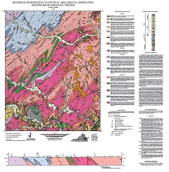
Geology by R.E. Weems. Compiled by M.E. Occhi and H.V. Shepherd, 34 x 35-inch color 1:24,000-scale geologic map, 2013. This map of the Montpelier 7.5-minute quadrangle in Hanover County, Virginia shows the distribution of Cenozoic-age unconsolidated sediments, Mesozoic-age igneous rocks, and Paleozoic- to Proterozoic-age metamorphic rocks in map and cross-section. A brief geologic summary is also provided. Online only.
Spacer Image