Virginia Department of EnergyAn official website of the Commonwealth of Virginia Here's how you knowAn official websiteHere's how you know

  HyperLink
Sign In Sign In Sign Out Logout Account Account Cart Cart
 
  SEARCH    Help?         Why do we use cookies?       Privacy Policy/Disclaimer
    Home

Product Categories


Sales & Returns Policy


Spacer Image

Spacer Image
Spacer ImageOpen File Report 11-11 Geologic Map of the Roxbury Quadrangle, Virginia
Spacer Image Spacer Image
Spacer Image
Spacer ImageYour Price: $0.00
Spacer ImageModel Number: 3041

Spacer Image
Spacer Image
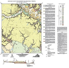
By A.K. Gilmer and C.R. Berquist, Jr., 33 x 33-inch color 1:24,000-scale geologic map, 2011. This map of the Roxbury 7.5-minute quadrangle in King William and New Kent counties, Virginia shows the distribution of Cenozoic-age unconsolidated Coastal Plain sediments in map and cross-section. Alluvium and modified land are also shown. Online only.
Spacer Image