HyperLink
Sign In Sign In Sign Out Logout Account Account Cart Cart
 
  SEARCH    Help?         Why do we use cookies?       Privacy Policy/Disclaimer
    Home

Product Categories


Sales & Returns Policy


Spacer Image

Spacer Image
Spacer ImageOpen File Report 11-10 Preliminary Surficial Geologic Map of the Luray Quadrangle, Virginia
Spacer Image Spacer Image
Spacer Image
Spacer ImageYour Price: $0.00
Spacer ImageModel Number: 3040

Spacer Image
Spacer Image
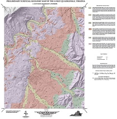
By L.S. Eaton and B.A. Fitzwater, 28 x 29-inch color 1:24,000-scale geologic map, 2011. This map of the Luray 7.5-minute quadrangle in Rockbridge County, Virginia shows a preliminary assessment of the distribution of Cenozoic-age alluvial and collluvial deposits. Online only.
Spacer Image