Virginia Department of EnergyAn official website of the Commonwealth of Virginia Here's how you knowAn official websiteHere's how you know

  HyperLink
Sign In Sign In Sign Out Logout Account Account Cart Cart
 
  SEARCH    Help?         Why do we use cookies?       Privacy Policy/Disclaimer
    Home

Product Categories


Sales & Returns Policy


Spacer Image

Spacer Image
Spacer ImageOpen File Report 09-05 Geologic Map of a Portion of the Cedar Springs Quadrangle, Virginia
Spacer Image Spacer Image
Spacer Image
Spacer ImageYour Price: $0.00
Spacer ImageModel Number: 3036

Spacer Image
Spacer Image
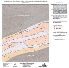
By W.W. Whitlock, 29 x 29-inch color 1:24,000-scale geologic map, 2009. This map of the central portion of the Cedar Springs 7.5-minute quadrangle in Grayson, Smyth, and Wythe counties, Virginia shows the distribution of Paleozoic-age sedimentary and metamorphic rocks in map and cross-section. Online only.
Spacer Image