
|
Your Price: $0.00
Model
Number: 3023
|
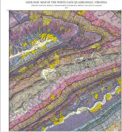
By A.P. Schultz, M.J. Bartholomew, E.K. Brown, and G.R. Ingram, 34 x 51.5-inch color 1:24,000-scale geologic map and report, 2019. This map of the White Gate 7.5-minute quadrangle in Bland, Giles, and Pulaski counties, Virginia shows the distribution of Paleozoic-age sedimentary rocks in map and cross-section. Surficial deposits including alluvium, colluvium, and landslides are also shown. The characteristics of each map unit are described and a brief report discusses the stratigraphy and structure of the area. Online only.
|
|