HyperLink
Sign In Sign In Sign Out Logout Account Account Cart Cart
 
  SEARCH    Help?         Why do we use cookies?       Privacy Policy/Disclaimer
    Home

Product Categories


Sales & Returns Policy


Spacer Image

Spacer Image
Spacer ImageOpen File Report 08-01 Bedrock geologic map of the Augusta Springs quadrangle, Virginia
Spacer Image Spacer Image
Spacer ImageIn Stock
Spacer ImageYour Price: $8.00
Spacer ImageModel Number: 2633

Spacer Image
Spacer Image
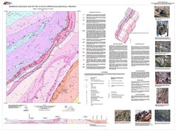
by L.V. Coiner and G.P. Wilkes, 34- x 44-inch color 1:24,000-scale geologic map, 2008. This map of the Augusta Springs 7.5-minute quadrangle in Augusta and Rockbridge Counties, Virginia shows the distribution of Paleozoic-age sedimentary rocks in map and cross-section. The characteristics of each map unit are described. Structural data and mineral resource locations are shown on the map.
Spacer Image