
|
Your Price: $0.00
Model
Number: 2629
|
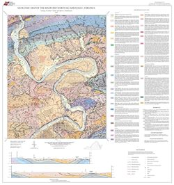
by A.P. Schultz and M.J. Bartholomew, 32- x 34-inch color 1:24,000-scale geologic map, 2009. This map of the Radford North 7.5-minute quadrangle in Montgomery, Pulaski and Giles Counties, Virginia shows the distribution of Paleozoic sedimentary rocks and Cenozoic surficial deposits in map and cross-section. The characteristics of each map unit are described. Sinkhole and mineral resource locations are also shown on the map. Online only.
|
|