
|
In Stock
Your Price: $7.00
Model
Number: 1096

|
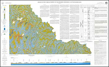
by W.W. Whitlock, full-color map with text, one-sheet, scale 1:24,000, 1989. Map shows the geology and mineral resources of the Virginia portion of the Patterson, Bradshaw, and War 7.5-minute quadrangles. The map area is located in the southwestern part of Virginia in Buchanan County. It lies entirely within the Appalachian Plateaus physiographic province and is characterized by steep-sloped ridges and narrow valleys. The bedrock in these quadrangles extends from the Mississippian-age Bluestone Formation to the Pennsylvanian Wise Formation. Generally, the strata in the map area have a dip of approximately 1 degree to the northeast. Coal is the primary mineral/energy resource in the map area. Fifteen coal beds have been mapped with mines producing from thirteen coal beds. Other mineral/energy resources include natural gas, shale and siltstone, clay, and sandstone. Map includes cross-section.
|
|