
|
Publication 121: Geology of the Virginia portion of the Hurley, Panther, Wharncliffe and Majestic quadrangles
|
|
|
In Stock
Your Price: $8.25
Model
Number: 1118

|
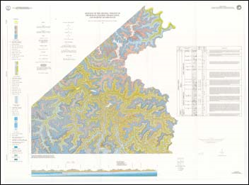
by J.A. Lovett, W.W. Whitlock, W.S. Henika, and R.N. Diffenbach, 10 pages, geologic map, scale 1:24,000, full-color, 1992. Map shows the geology and mineral resources of the Virginia portion of the Hurley, Panther, Wharncliffe, and Majestic 7.5-minute quadrangles. The map area is located in the southwestern part of Virginia in Buchanan County. It lies entirely within the Appalachian Plateaus physiographic province and is characterized by steep-sloped ridges and narrow valleys. The bedrock in these quadrangles ranges in age from Lower to Middle Pennsylvanian. Generally the strata in the map area have a dip of approximately 0.5 to 1.5 degrees to the northwest. Coal is the primary mineral/energy resource in the map area. Fourteen coal beds have been mapped and many of these coals have been mined by surface and underground methods. Other mineral/energy resources include natural gas, shale and siltstone, clay, and sandstone. Map includes cross-section.
|
|
|
|
|
|
|