HyperLink
Sign In Sign In Sign Out Logout Account Account Cart Cart
 
  SEARCH    Help?         Why do we use cookies?       Privacy Policy/Disclaimer
    Home

Product Categories


Sales & Returns Policy


Spacer Image

Spacer Image
Spacer ImagePublication 052: Geology of the Prater and Vansant quadrangles, Virginia
Spacer Image Spacer Image
Spacer ImageIn Stock
Spacer ImageYour Price: $6.00
Spacer ImageModel Number: 1044

Spacer Image
Spacer Image
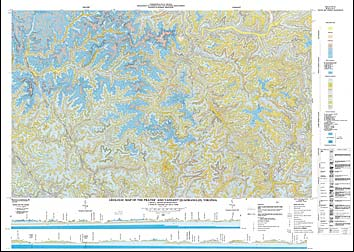
by J.E. Nolde, M.L. Mitchell, and J.K. Polzin, multicolored geologic map with 28 page text, 1984. Map shows the geology and mineral resources of the Prater and Vansant 7.5-minute quadrangles. The map area is located in the southwestern part of Virginia in Buchanan and Dickenson counties. It lies entirely within the Appalachian Plateaus physiographic province and is characterized by steep-sloped ridges and narrow valleys. The bedrock in these quadrangles ranges in age from Lower to Middle Pennsylvanian. Generally, the strata in the map area have a gentle northwest regional dip. Coal is the primary mineral/energy resource in the map area. Twenty coal beds crop out in the quadrangles, seven of which have been mined. Other mineral/energy resources include natural gas, shale and siltstone, clay, and sandstone. Map includes cross-sections.
 Customers who bought this also bought
  Publication 086: Geology of the Virginia Portion of the Clintwood and Jenkins East Quadrangles
  Publication 080: Geology of the Wise Quadrangle, and the Coal-bearing Portion of the Fort Blackmore Quadrangle, Virginia
  Publication 081: Geology of the Coeburn Quadrangle and the Coal-bearing Portion of the Dungannon Quadrangle, Virginia
  Publication 091: Geology of the Haysi Quadrangle, Virginia
  Publication 092: Geology of the Nora quadrangle, Virginia
 
Spacer Image