
|
In Stock
Your Price: $8.00
Model
Number: 1074

|
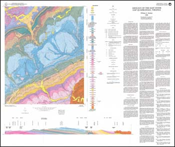
by W.S. Henika, folded 40 x 34-inch color 1:24,000-scale geologic map with explanation and 5 x 55-inch black and white stratigraphic section from gamma-ray logs, 1988. Geologic map and explanation describe the stratigraphy, structure, and economic geology of the East Stone Gap 7.5-minute quadrangle in Wise and Scott counties. Appalachian Plateaus and Valley and Ridge sedimentary rocks and recent allluvium and colluvium are delineated with cross-section and stratigraphic column with outcrop-derived gamma ray log. Crushed stone quarries and mine adits for coal, oil and gas test wells and limonite prospect are plotted. Repository sample locations of coal and clay material analyses as well as measured locations are depicted. The detailed economic geology section discusses coal, gas and oil, limestone and dolostone for crushed stone (with L.A. abrasion tests), sandstone, clay and shale for economic potential.
|
|