
|
In Stock
Your Price: $7.50
Model
Number: 1092

|
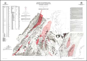
by G.P. Wilkes, S.S. Johnson and R.C. Milici, 2 folded 48 x 36-inch limited color 1:500,000-scale maps with explanation, 1989. Gravity and aeromagnetic maps depicting the areal extent of both exposed and buried Triassic basins in Virginia, east of the -80 degree longitude. Overview of the project and the general geology of the basins included. Buried basin extents were derived from drill hole data. Gravity map displays simple Bouger gravity anomaly contours onshore and in the Chesapeake Bay and free air anomaly contours offshore with drill hole locations. Aeromagnetic map shows contour of the total intensity magnetic field of the earth and measured extreme intensity values within closed high or low contours and drill hole locations. Data for drill holes also presented in tabular format with designation, name, total depth (feet), lithology at TD, depth of Mesozoic/Cretacous contact (feet) and basement contact (feet), as applicable.
|
|