HyperLink
Sign In Sign In Sign Out Logout Account Account Cart Cart
 
 
   Help?         Why do we use cookies?       Privacy Policy/Disclaimer
    Home

SURVEY

Product Categories


Sales & Returns Policy

Mastercard LogoVisa Logo


Spacer Image

Spacer Image
Spacer ImageReport of Investigations 011: Geology of the Leesburg Quadrangle, Virginia
Spacer Image Spacer Image
Spacer ImageVirginia Energy Mineral Logo Spacer Image
Spacer ImageIn Stock
Spacer ImageYour Price: $6.00
Spacer ImageModel Number: 1179

Spacer ImageAdd to Cart
Spacer Image
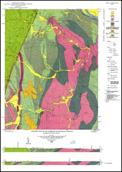
E.C. Toewe, 6 x 9-inch soft cover book, 52 pages, one plate includes folded 23 x 32.5-inch color 1:24,000-scale geologic map, 14 figures, six tables, 1966. This map and report portray and describe the stratigraphy, structure, economic geology, and groundwater resources of the Leesburg 7.5-minute quadrangle in Loudon County. Triassic-age sedimentary rocks, Blue Ridge cover rocks, and recent alluvium are mapped in the area. Quarries and prospects for crushed stone, lime and copper are shown on the map as well as rock and fossil repository samples. Measured sections, whole rock analyses and geologic logs of cores of diabase are included.
 Customers who bought this also bought
  Geologic Map Of Virginia (1:500,000)
  Publication 102: Geologic Map of Clarke County, Virginia and Map of Selected Hydrogeologic Components for Clarke County, Virginia
  Boxed Set of Twenty Rocks and Minerals from Virginia
  Publication 165: Geologic Map of the Western Portion of the Richmond 30 X 60-minute Quadrangle, Virginia
  Bulletin 078: Geology and Mineral Resources of Greene and Madison Counties
 
Spacer Image