HyperLink
Sign In Sign In Sign Out Logout Account Account Cart Cart
 
  SEARCH    Help?         Why do we use cookies?       Privacy Policy/Disclaimer
    Home

SURVEY

Product Categories


Sales & Returns Policy


Spacer Image

Spacer Image
Spacer ImageReport of Investigations 002: Geology of the Williamsville Quadrangle, Virginia
Spacer Image Spacer Image
Spacer ImageIn Stock
Spacer ImageYour Price: $5.00
Spacer ImageModel Number: 1170

Spacer Image
Spacer Image
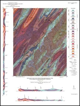
K.F. Bick, 20 x 27-inch color 1:62,500-scale geologic map, 1962. This map portrays and describes the stratigraphy, structure, and economic geology of the Williamsville 15-minute quadrangle in Bath and Highland counties with cross-sections. Valley and Ridge sedimentary rocks are mapped in the area. Several measured sections are included in the text. Iron, manganese, limestone and sandstone resources are briefly described. No locations of quarries and prospects on map. Map area includes Williamsville, Burnsville, Bath Alum, and Green Valley 7.5-minute quadrangles. The text for this product is out-of-print, but can be downloaded in PDF format. The map is still available for purchase in hard copy format.
 Customers who bought this also bought
  Report of Investigations 021: Geology of the Elliot Knob, Deerfield, Craigsville and Augusta Springs Quadrangles, Virginia
  Report of Investigations 008: Geology of the Millboro Quadrangle, Virginia
  Report of Investigations 001: Geology of the Lexington Quadrangle, Virginia
  Report of Investigations 007: Geology of the Vesuvius Quadrangle, Virginia
  Publication 065: Geology of the Norton Quadrangle, Virginia
 
Spacer Image