
|
In Stock
Your Price: $6.00
Model
Number: 1007

|
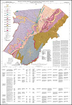
by E.K. Rader and H.W. Webb, environmental-geologic map at 1:50,000 scale with text and table, 1979. This map of Warren County was prepared by grouping together lithologic units that have similar properties of residuum and bedrock, and could have similar effects upon human occupation. Observed rock types, slope stability, joints, erodibility, and natural hazards were considered when compiling the maps. This map should be used only as a general guide to the distribution of broad geologic units with similar physical properties. Table 1 lists the characteristics of each unit. The report discusses soils, sinkholes and caves, rockfalls, and landslides.
|
|
|
|
Customers who bought this also bought
|
Report of Investigations 035: Geology of the Woodstock, Wolf Gap, Conicville and Edinburg Quadrangles, Virginia
|
Publication 138: Geologic Map of Warren County, Virginia
|
Geologic Map Of Virginia (1:500,000)
|
Bulletin 081: Geology and Mineral Resources of Page County
|
Publication 162: Geologic Map of the Front Royal 30 x 60-minute Quadrangle: Portions of Clarke, Page, Rockingham, Shenandoah, and Warren Counties, Virginia
|
|
|
|