HyperLink
Sign In Sign In Sign Out Logout Account Account Cart Cart
 
  SEARCH    Help?         Why do we use cookies?       Privacy Policy/Disclaimer
    Home

Product Categories


Sales & Returns Policy


Spacer Image

Spacer Image
Spacer ImagePublication 012: Geology of the Fort Defiance Quadrangle, Virginia
Spacer Image Spacer Image
Spacer ImageIn Stock
Spacer ImageYour Price: $6.00
Spacer ImageModel Number: 1004

Spacer Image
Spacer Image
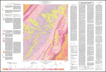
by T.M. Gathright, II, W.S. Henika and J.L. Sullivan, III, folded 42 x 29-inch color 1:24,000-scale geologic map with explanation, 1978. Geologic map and explanation briefly describe the stratigraphy, structure, and economic geology of the Fort Defiance 7.5-minute quadrangle in Augusta County. Valley and Ridge sedimentary rocks, Mesozoic igneous rocks, and recent allluvium are delineated on the geologic map with cross-sections. Abandoned crushed stone quarries, rock and fossil repository sample locations are depicted. Includes a description of how each bedrock type may affect land use.
 Customers who bought this also bought
  Publication 010: Geology of the Grottoes Quadrangle, Virginia
  Elkton East, VA Topographic Map (1:24,000)
  Elkton West, VA Topographic Map (1:24,000)
  Grottoes, VA Topographic Map (1:24,000)
  McGaheysville, VA Topographic Map (1:24,000)
 
Spacer Image