HyperLink
Sign In Sign In Sign Out Logout Account Account Cart Cart
 
 
   Help?         Why do we use cookies?       Privacy Policy/Disclaimer
    Home

SURVEY

Product Categories


Sales & Returns Policy

Mastercard LogoVisa Logo


Spacer Image

Spacer Image
Spacer ImageOpen File Report 2022-15 Geologic Map of the Fine Creek Mills Quadrangle, Virginia
Spacer Image Spacer Image
Spacer ImageVirginia Energy Mineral Logo Spacer Image
Spacer Image
Spacer ImageYour Price: $0.00
Spacer ImageModel Number: 3099

Spacer Image
Spacer Image
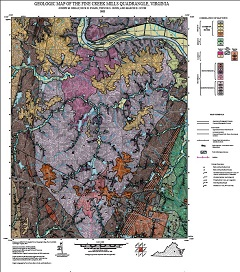
By J.M. Reilly, N.H. Evans, T.S. Gunn, M.E. Occhi, 34 x 34-inch color 1:24,000-scale geologic map, 2021. Map of the Fine Creek Mills 7.5-minute quadrangle in Powhatan and Goochland counties, Virginia shows the distribution of Proterozoic-age igneous and metamorphic rocks, Paleozoic- age metamorphic rocks, mesozoic-age sedimentary rocks in map and cross-section. Surficial deposits including terrace and alluvial deposits are also shown. Online only.
Spacer Image