HyperLink
Sign In Sign In Sign Out Logout Account Account Cart Cart
 
  SEARCH    Help?         Why do we use cookies?       Privacy Policy/Disclaimer
    Home

Product Categories


Sales & Returns Policy


Spacer Image

Spacer Image
Spacer ImageOpen File Report 15-05 Interstate 81 Corridor Digital Geologic Compilation: South Half of Stanley Quadrangle, Virginia
Spacer Image Spacer Image
Spacer Image
Spacer ImageYour Price: $0.00
Spacer ImageModel Number: 3065

Spacer Image
Spacer Image
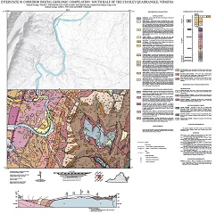
By S.J. Whitmeyer, J. Kirby, A.C. Witt, and M.J. Heller, 33 x33-inch color 1:24,000-scale geologic map, 2015. This map of the south half of the Stanley 7.5-minute quadrangle in Page and Rockingham counties, Virginia shows the distribution of Paleozoic-age sedimentary and Paleozoic- to Proterozoic-age metamorphic rocks in map and cross-section. Surficial deposits including alluvium. fans, and river terraces are also shown. Online only.
Spacer Image