
|
Your Price: $0.00
Model
Number: 2644
|
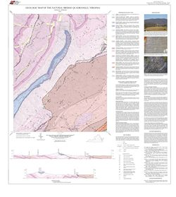
by E.W. Spencer, 34- x 38-inch color 1:24,000-scale geologic map, 2010. This revised map of the Natural Bridge 7.5-minute quadrangle in Rockbridge County shows the distribution of Paleozoic-age sedimentary rocks in map and cross-section. Alluvium is also shown. This map also contains notes about the revision to the original map, which is available as part of Virginia Division of Mineral Resources Report of Investigation 13. Only available online.
|
|