
|
Publication 102: Geologic Map of Clarke County, Virginia and Map of Selected Hydrogeologic Components for Clarke County, Virginia
|
|
|
In Stock
Your Price: $13.00
Model
Number: 1099

|
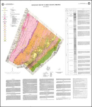
D.A. Hubbard, Jr., one folded 38.5 x 44.5-inch color 1:50,000-scale geologic map and one folded 29 x 45-inch limited color 1:50,000-scale hydrogeologic component map, 1990. Geologic map with surficial deposits of Clarke County, Virginia includes a stratigraphic column with unit descriptions. Brief discussion of geologic structure and economic geology. The economic section describes: industrial limestone and dolomite; travertine-marl; clay, shale, and related materials; high-silica sand; barite; flourite; iron; and copper and lead. Locations of active and inactive quarries and pits, prospects, sample location and rock repository sampled plotted. The hydrogeologic map depicts lithologic contacts, faults, springs, sinkholes, caves, and LANDSAT lineament zones with discussion.
|
|
|
|
Customers who bought this also bought
|
Publication 143: Geologic Map of Clarke, Frederick, Page, Shenandoah, and Warren Counties, Virginia: Lord Fairfax Planning District
|
Publication 138: Geologic Map of Warren County, Virginia
|
Report of Investigations 034: Geology of the Berryville, Stephenson, and Boyce Quadrangles, Virginia
|
Bulletin 080: Geology and Mineral Resources of Frederick County
|
Geologic Map Of Virginia (1:500,000)
|
|
|
|
|
|
|
|
|