HyperLink
Sign In Sign In Sign Out Logout Account Account Cart Cart
 
  SEARCH    Help?         Why do we use cookies?       Privacy Policy/Disclaimer
    Home

Product Categories


Sales & Returns Policy


Spacer Image

Spacer Image
Spacer ImagePublication 098: Geology of the Virginia Portion of the Harman and Jamboree Quadrangles
Spacer Image Spacer Image
Spacer ImageIn Stock
Spacer ImageYour Price: $7.00
Spacer ImageModel Number: 1095

Spacer Image
Spacer Image
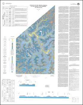
by W.S. Henika, folded 39 x 49-inch color 1:24,000-scale geologic map with explanation, 1989. Geologic map and text describe the stratigraphy, structure and economic geology of the Virginia portions of the Harman and Jamboree 7.5-minute quadrangles in Buchanan County. Appalachian Plateaus sedimentary rocks and recent alluvium are delineated with cross-section and stratigraphic column. Detailed discussion of coal with brief discussion of natural gas, shale, siltstone and sandstone historic use. Active and inactive mine adits, gas and oil test wells, coal outcrop locations are plotted. Repository sample locations for coal are depicted.
 Customers who bought this also bought
  Publication 091: Geology of the Haysi Quadrangle, Virginia
  Publication 092: Geology of the Nora quadrangle, Virginia
  Publication 121: Geology of the Virginia portion of the Hurley, Panther, Wharncliffe and Majestic quadrangles
  Publication 097: Geology of the Grundy Quadrangle, Virginia
  Publication 084: Geology of the Pound and Caney Ridge Quadrangles, Virginia
 
Spacer Image